


Take the stress out of Sunday night, by having your lesson planning done for you. Feel confident in front of your class because this curriculum includes everything that you need to engage your students and teach to the standard.
Best of all, no expertise or prior knowledge in Forestry is required.
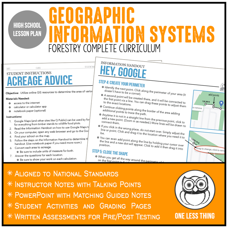
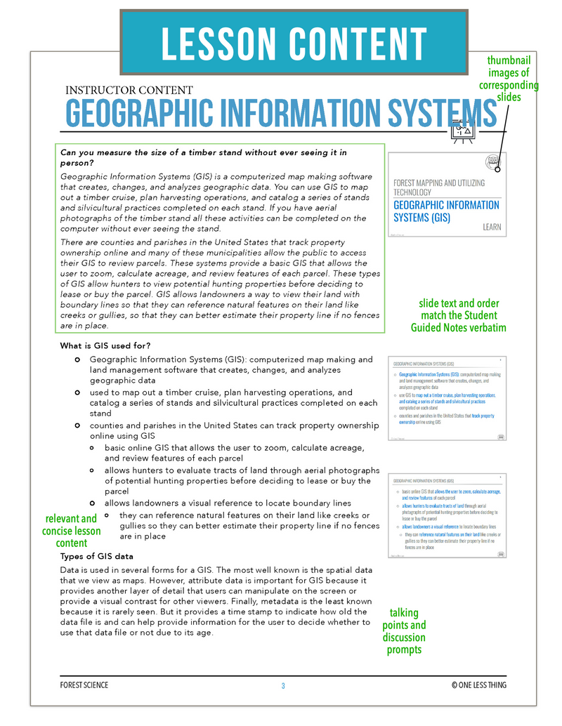
This lesson is on geographic information systems and covers what GIS is used for, types of GIS data, GPS data, benefits of GIS, origins of GPS, and the difference between GPS and GIS.
The included lab activity has all the handouts and instructions you need for students to apply the practical skills to create a map and collect data using Google Maps.
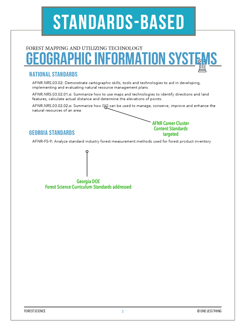
It is aligned to the National AFNR Standards for Natural Resources and the Georgia Curriculum Standards for Forestry Science.
Included in the digital downloads are:
- Instructor Guides
- Content Outline with Talking Points
- Matching PowerPoint
- Student Guided Notes
- Written Assessment for Pre/Post Test
- Student Lab Pages
- Lab Assessments
- Answer Keys for Everything
This lesson is part of the Forestry Science curriculum but can be added to any high school agriculture class. Anyone can use this lesson to teach Forestry, even a substitute teacher.
How It Works:
After completing your purchase, simply check your email for a download link and you are good to go. Download the PDFs and PowerPoints and begin using the curriculum right away.
Use it to teach this lesson verbatim or add it as a supplement to your current curriculum and get time back to spend with your family.
If you want your whole year done for you, check out the rest of the Complete Curriculum for Forestry Science here.
Our shipping is based on total order amount. Shipping will be automatically calculated when shopping online. (There is no shipping charged on digital download products. I mean who would do that really?)
We ship by UPS. You will receive a tracking number when your order ships.
If you are completing a School Purchase Order or if you just want to estimate your total expenses use the following information:
- For order totals $100 and under ---- add $15
- For order totals $101 to $340 ---- add $20
- Order totals over $350 ---- add $30
- Make sure to provide a physical address...UPS will NOT deliver to a Post Office box. We tried. Then we received a firm talking to and we had to go to bed without dinner. Please don't make us try that again.
Take the stress out of Sunday night, by having your lesson planning done for you. Feel confident in front of your class because this curriculum includes everything that you need to engage your students and teach to the standard.
Best of all, no expertise or prior knowledge in Forestry is required.
This lesson is on geographic information systems and covers what GIS is used for, types of GIS data, GPS data, benefits of GIS, origins of GPS, and the difference between GPS and GIS.
The included lab activity has all the handouts and instructions you need for students to apply the practical skills to create a map and collect data using Google Maps.
It is aligned to the National AFNR Standards for Natural Resources and the Georgia Curriculum Standards for Forestry Science.
Included in the digital downloads are:
- Instructor Guides
- Content Outline with Talking Points
- Matching PowerPoint
- Student Guided Notes
- Written Assessment for Pre/Post Test
- Student Lab Pages
- Lab Assessments
- Answer Keys for Everything
This lesson is part of the Forestry Science curriculum but can be added to any high school agriculture class. Anyone can use this lesson to teach Forestry, even a substitute teacher.
How It Works:
After completing your purchase, simply check your email for a download link and you are good to go. Download the PDFs and PowerPoints and begin using the curriculum right away.
Use it to teach this lesson verbatim or add it as a supplement to your current curriculum and get time back to spend with your family.
If you want your whole year done for you, check out the rest of the Complete Curriculum for Forestry Science here.
Our shipping is based on total order amount. Shipping will be automatically calculated when shopping online. (There is no shipping charged on digital download products. I mean who would do that really?)
We ship by UPS. You will receive a tracking number when your order ships.
If you are completing a School Purchase Order or if you just want to estimate your total expenses use the following information:
- For order totals $100 and under ---- add $15
- For order totals $101 to $340 ---- add $20
- Order totals over $350 ---- add $30
- Make sure to provide a physical address...UPS will NOT deliver to a Post Office box. We tried. Then we received a firm talking to and we had to go to bed without dinner. Please don't make us try that again.